Introduction - a brief history
"we must deal with the reality ... the evidence of logging cannot be hidden from view" says the front cover of the Forest Landscape Handbook published by the BC Forest Service in 1981.
Based on the Visual Management System developed by the USFS in 1974, the FL Handbook, authored by Pem van Heek, introduced to BC a comprehensive explanation of landscape inventory and design, and a system of "visual quality objectives" for managing alterations in scenic areas.
By 1987, when Pem van Heek retired, there was a recreation officer in each Forest Service district office who was mainly concerned with mapping visually sensitive areas, and a visual landscape forester coordinating information collection in each of the six regional offices. These staff, and visual consultants, mapped approximately 15% of BC's forest as being visually sensitive to some degree.
Mapping of the province's scenic areas was largely complete by 1993. The Forest Service then moved into operational implementation. Development plans were reviewed and approved considering visual objectives, and Visual Impact Assessments became a routine test by the Forest Service to assess visual impacts of proposed operations.
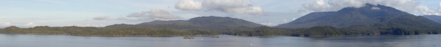
The Timber Supply Review, then underway, found that harvest restrictions due to visual quality objectives (VQOs) would have a noticeable impact on harvest levels and economic activity in the province. Interest increased in developing a science-based rationale for the establishment of VQOs, and ways to harvest timber in visually sensitive areas without unduly disturbing the view.
Research projects
In response to TSR concerns, a public perception study of the height and years for regenerating forests to reach "visually effective green-up" was undertaken and published in 1994. The main finding of that research was that on average trees on mid-ground slopes need to achieve 5 to 6 metres height before the new forest gains visual acceptance from the public.

Meanwhile, a public perception study of clearcut harvest patterns and intensities in scenic areas was underway. The study showed photographs of a range of alterations to citizens throughout BC. A report with colour photographs, summarizing results, was published in 1996. The research as well as other research reports demonstated that the public have an acceptance of harvesting up to about 6 to 7% of the measured perspective view.

The zone of public acceptance of harvesting, 1.5% to 7% alteration in perspective view, is known as "Partial Retention". The finding of a 7% upper limit to acceptable alteration set off investigations of perspective versus plan views of the landscape. Viewers see the land in perspective, while forest inventory and analysis gather data in plan view from maps. Research quantified how tree height (foreground screening) and terrain slope contribute to what can be seen.
By 1999, software research provided the capability of making design lines appear on a 3-D image of the landform on a computer screen, while digitizing roads and harvest unit boundaries on a map laid over a tablet. Consultants responded with many sophisticated visualization systems that were used to produce the visual impact assessments required under the Forest Practices Code.
Onging public perception studies gathered field data and queried citizens about their acceptance of partial cutting and variable retention alterations. The Forest Service published reports on both topics. An integrated perception study published in 2006 looked at all three principal silviculture systems at both the landscape and stand level. The survey sampled tourists and forest professionals in addition to BC citizens.
Follow-up: Step 5 in the FL Handbook, 1981
The Forest and Range Practices Act (FRPA) replaced the Forest Practices Code in 2004. Changes to forestry management were phased in over the following two years. FRPA identifies scenery as one of the eleven forest values to be managed, and defines the categories of visually altered forest landscapes in clear terminology. Under FRPA authority, District managers have established visual quality objectives for scenic areas throughout BC. Forest Stewardship Plans are required to specify results and strategies for managing the visual resource where applicable.
These initiatives require post-harvest follow-up to ensure compliance with plans and objectives. While answering only questions 3 and 4 posed in the sidebar to the left, effectiveness evaluation procedures and a field form were developed to enable standardized audit of harvests on landforms in scenic areas.
The procedures combine assessment using the written legal definitions in FRPA with numeric and qualitative methods learned from research over the past decade. Alterations are photographed and measured for compliance within ranges of alteration as determined in the public perception studies. The procedures were field-tested by the Forest Practices Board in an audit of visual resource management in Campbell River Forest District, 2005. The procedures were found to be robust, and are presently used by district staff to assess compliance with visual quality objectives in many areas of BC.
Mr. Olivotto was involved in field data collection, assessment, and write-ups as required, for all the projects discussed above, that have been published since 1990.
References
Forest Service Visuals home pageVisual Landscape Inventory Manual
Visual Landscape Design Manual
Visual Impact Assessment Guidebook (pre-harvest)
Visual Quality Effectiveness Evaluation (post-harvest)